|
|
|||||||||||||||||
| Point ID: 9677 | Downloads | Plots | Site Data | Code: 05078230 |
|
|
|||||||||||||||||
| Download | |
|---|---|
| Site Descriptor Information | Site Time Series Data |
| Link to all available data | |
| View: | Time Series | All |
| Units: | mm |
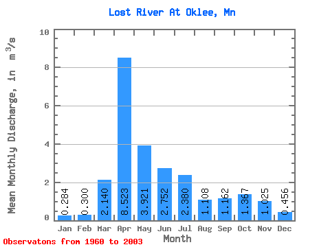
| Statistic | Jan | Feb | Mar | Apr | May | Jun | Jul | Aug | Sep | Oct | Nov | Dec | Annual |
|---|---|---|---|---|---|---|---|---|---|---|---|---|---|
| Mean | 0.28 | 0.30 | 2.14 | 8.52 | 3.92 | 2.75 | 2.38 | 1.11 | 1.16 | 1.37 | 1.02 | 0.46 | 2.17 |
| Standard Deviation | 0.21 | 0.34 | 2.07 | 7.12 | 3.41 | 3.09 | 2.84 | 1.92 | 1.90 | 2.15 | 1.34 | 0.35 | 1.05 |
| Min | 0.00 | 0.00 | 0.01 | 0.83 | 0.30 | 0.23 | 0.06 | 0.03 | 0.00 | 0.03 | 0.03 | 0.00 | 0.48 |
| Max | 0.76 | 2.16 | 7.48 | 25.60 | 17.61 | 18.60 | 12.52 | 9.93 | 9.35 | 13.31 | 6.56 | 1.60 | 5.05 |
| Coefficient of Variation | 0.73 | 1.14 | 0.97 | 0.84 | 0.87 | 1.12 | 1.19 | 1.74 | 1.64 | 1.57 | 1.31 | 0.77 | 0.48 |
 Return to R-Arctic Net Home Page