|
|
|||||||||||||||||
| Point ID: 9677 | Downloads | Plots | Site Data | Code: 05078230 |
|
|
|||||||||||||||||
| Download | |
|---|---|
| Site Descriptor Information | Site Time Series Data |
| Link to all available data | |
| View: | Time Series | All |
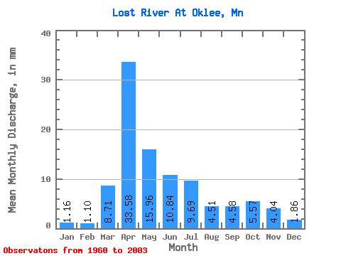
| Units: | m3/s |
| Statistic | Jan | Feb | Mar | Apr | May | Jun | Jul | Aug | Sep | Oct | Nov | Dec | Annual |
|---|---|---|---|---|---|---|---|---|---|---|---|---|---|
| Mean | 1.16 | 1.11 | 8.71 | 33.58 | 15.96 | 10.84 | 9.69 | 4.51 | 4.58 | 5.56 | 4.04 | 1.85 | 104.03 |
| Standard Deviation | 0.85 | 1.27 | 8.41 | 28.07 | 13.87 | 12.18 | 11.54 | 7.83 | 7.50 | 8.76 | 5.29 | 1.43 | 50.40 |
| Min | 0.00 | 0.00 | 0.02 | 3.29 | 1.21 | 0.92 | 0.23 | 0.13 | 0.00 | 0.12 | 0.12 | 0.01 | 23.01 |
| Max | 3.08 | 8.02 | 30.45 | 100.85 | 71.70 | 73.29 | 50.98 | 40.41 | 36.85 | 54.18 | 25.86 | 6.53 | 242.19 |
| Coefficient of Variation | 0.73 | 1.14 | 0.97 | 0.84 | 0.87 | 1.12 | 1.19 | 1.74 | 1.64 | 1.57 | 1.31 | 0.77 | 0.48 |
 Return to R-Arctic Net Home Page