|
|
|||||||||||||||||
| Point ID: 9672 | Downloads | Plots | Site Data | Code: 05056100 |
|
|
|||||||||||||||||
| Download | |
|---|---|
| Site Descriptor Information | Site Time Series Data |
| Link to all available data | |
| View: | Time Series | All |
| Units: | mm |
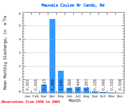
| Statistic | Jan | Feb | Mar | Apr | May | Jun | Jul | Aug | Sep | Oct | Nov | Dec | Annual |
|---|---|---|---|---|---|---|---|---|---|---|---|---|---|
| Mean | 0.00 | 0.01 | 0.62 | 5.49 | 1.64 | 0.37 | 0.44 | 0.40 | 0.13 | 0.07 | 0.03 | 0.01 | 0.54 |
| Standard Deviation | 0.00 | 0.03 | 1.32 | 7.65 | 2.97 | 0.55 | 1.06 | 1.25 | 0.37 | 0.18 | 0.07 | 0.02 | 0.61 |
| Min | 0.00 | 0.00 | 0.00 | 0.00 | 0.00 | 0.00 | 0.00 | 0.00 | 0.00 | 0.00 | 0.00 | 0.00 | 0.00 |
| Max | 0.01 | 0.14 | 5.61 | 26.77 | 14.91 | 2.48 | 6.39 | 7.76 | 1.77 | 0.77 | 0.29 | 0.11 | 2.04 |
| Coefficient of Variation | 3.26 | 5.15 | 2.13 | 1.39 | 1.81 | 1.50 | 2.38 | 3.16 | 2.92 | 2.67 | 2.20 | 2.77 | 1.14 |
 Return to R-Arctic Net Home Page