|
|
|||||||||||||||||
| Point ID: 9672 | Downloads | Plots | Site Data | Code: 05056100 |
|
|
|||||||||||||||||
| Download | |
|---|---|
| Site Descriptor Information | Site Time Series Data |
| Link to all available data | |
| View: | Time Series | All |
| Units: | m3/s |
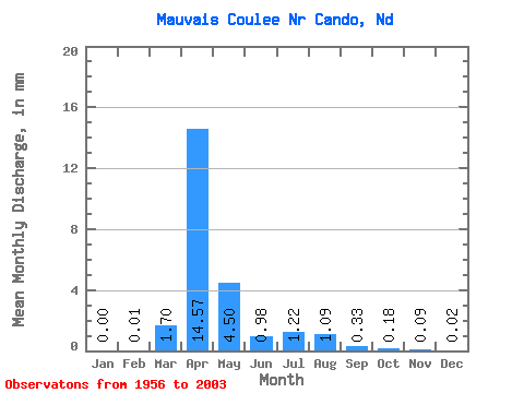
| Statistic | Jan | Feb | Mar | Apr | May | Jun | Jul | Aug | Sep | Oct | Nov | Dec | Annual |
|---|---|---|---|---|---|---|---|---|---|---|---|---|---|
| Mean | 0.00 | 0.01 | 1.66 | 14.19 | 4.38 | 0.95 | 1.19 | 1.06 | 0.33 | 0.18 | 0.09 | 0.02 | 16.93 |
| Standard Deviation | 0.01 | 0.07 | 3.53 | 19.78 | 7.94 | 1.42 | 2.83 | 3.35 | 0.95 | 0.47 | 0.19 | 0.06 | 19.36 |
| Min | 0.00 | 0.00 | 0.00 | 0.00 | 0.00 | 0.00 | 0.00 | 0.00 | 0.00 | 0.00 | 0.00 | 0.00 | 0.00 |
| Max | 0.03 | 0.34 | 15.00 | 69.24 | 39.84 | 6.42 | 17.08 | 20.73 | 4.56 | 2.05 | 0.76 | 0.29 | 64.09 |
| Coefficient of Variation | 3.26 | 5.15 | 2.13 | 1.39 | 1.81 | 1.50 | 2.38 | 3.16 | 2.92 | 2.67 | 2.20 | 2.77 | 1.14 |
 Return to R-Arctic Net Home Page