|
|
|||||||||||||||||
| Point ID: 9662 | Downloads | Plots | Site Data | Code: 05030000 |
|
|
|||||||||||||||||
| Download | |
|---|---|
| Site Descriptor Information | Site Time Series Data |
| Link to all available data | |
| View: | Time Series | All |
| Units: | mm |
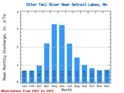
| Statistic | Jan | Feb | Mar | Apr | May | Jun | Jul | Aug | Sep | Oct | Nov | Dec | Annual |
|---|---|---|---|---|---|---|---|---|---|---|---|---|---|
| Mean | 0.69 | 0.69 | 0.96 | 2.20 | 3.26 | 3.22 | 2.18 | 1.41 | 1.01 | 0.83 | 0.71 | 0.74 | 1.54 |
| Standard Deviation | 0.49 | 0.45 | 0.56 | 1.37 | 1.86 | 2.01 | 1.47 | 1.63 | 1.21 | 0.82 | 0.64 | 0.56 | 0.66 |
| Min | 0.09 | 0.02 | 0.01 | 0.03 | 0.04 | 0.06 | 0.04 | 0.01 | 0.04 | 0.06 | 0.14 | 0.12 | 0.22 |
| Max | 1.61 | 1.70 | 2.36 | 5.39 | 7.51 | 8.05 | 5.82 | 8.15 | 6.75 | 3.92 | 2.98 | 2.20 | 3.38 |
| Coefficient of Variation | 0.71 | 0.64 | 0.58 | 0.62 | 0.57 | 0.62 | 0.67 | 1.16 | 1.20 | 0.99 | 0.90 | 0.76 | 0.43 |
 Return to R-Arctic Net Home Page