|
|
|||||||||||||||||
| Point ID: 9662 | Downloads | Plots | Site Data | Code: 05030000 |
|
|
|||||||||||||||||
| Download | |
|---|---|
| Site Descriptor Information | Site Time Series Data |
| Link to all available data | |
| View: | Time Series | All |
| Units: | m3/s |
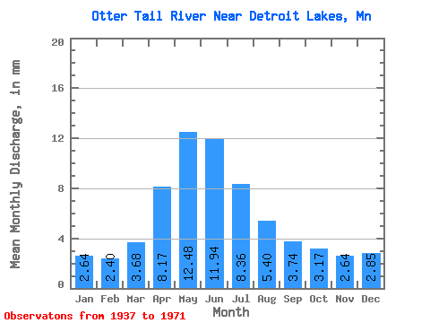
| Statistic | Jan | Feb | Mar | Apr | May | Jun | Jul | Aug | Sep | Oct | Nov | Dec | Annual |
|---|---|---|---|---|---|---|---|---|---|---|---|---|---|
| Mean | 2.64 | 2.42 | 3.68 | 8.17 | 12.48 | 11.94 | 8.36 | 5.40 | 3.74 | 3.17 | 2.64 | 2.85 | 69.42 |
| Standard Deviation | 1.89 | 1.55 | 2.13 | 5.07 | 7.12 | 7.46 | 5.62 | 6.24 | 4.50 | 3.13 | 2.37 | 2.16 | 29.74 |
| Min | 0.35 | 0.08 | 0.04 | 0.12 | 0.16 | 0.23 | 0.17 | 0.06 | 0.15 | 0.23 | 0.52 | 0.47 | 9.73 |
| Max | 6.18 | 5.94 | 9.02 | 20.00 | 28.75 | 29.84 | 22.30 | 31.21 | 25.04 | 15.02 | 11.03 | 8.42 | 152.70 |
| Coefficient of Variation | 0.71 | 0.64 | 0.58 | 0.62 | 0.57 | 0.62 | 0.67 | 1.16 | 1.20 | 0.99 | 0.90 | 0.76 | 0.43 |
 Return to R-Arctic Net Home Page