|
|
|||||||||||||||||
| Point ID: 9651 | Downloads | Plots | Site Data | Code: 05098800 |
|
|
|||||||||||||||||
| Download | |
|---|---|
| Site Descriptor Information | Site Time Series Data |
| Link to all available data | |
| View: | Time Series | All |
| Units: | mm |
| Statistic | Jan | Feb | Mar | Apr | May | Jun | Jul | Aug | Sep | Oct | Nov | Dec | Annual |
|---|---|---|---|---|---|---|---|---|---|---|---|---|---|
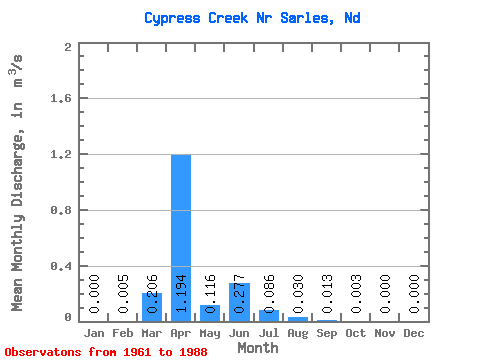
| Mean | 0.00 | 0.01 | 0.21 | 1.19 | 0.12 | 0.28 | 0.09 | 0.03 | 0.01 | 0.00 | 0.00 | 0.00 | 0.16 |
| Standard Deviation | 0.00 | 0.03 | 0.38 | 1.38 | 0.24 | 0.73 | 0.22 | 0.10 | 0.06 | 0.01 | 0.00 | 0.00 | 0.14 |
| Min | 0.00 | 0.00 | 0.00 | 0.00 | 0.00 | 0.00 | 0.00 | 0.00 | 0.00 | 0.00 | 0.00 | 0.00 | 0.01 |
| Max | 0.00 | 0.13 | 1.39 | 4.83 | 1.21 | 3.46 | 0.86 | 0.47 | 0.34 | 0.06 | 0.01 | 0.01 | 0.52 |
| Coefficient of Variation | 5.20 | 1.86 | 1.16 | 2.09 | 2.64 | 2.55 | 3.30 | 4.97 | 4.06 | 4.27 | 5.29 | 0.84 |
 Return to R-Arctic Net Home Page