|
|
|||||||||||||||||
| Point ID: 9651 | Downloads | Plots | Site Data | Code: 05098800 |
|
|
|||||||||||||||||
| Download | |
|---|---|
| Site Descriptor Information | Site Time Series Data |
| Link to all available data | |
| View: | Time Series | All |
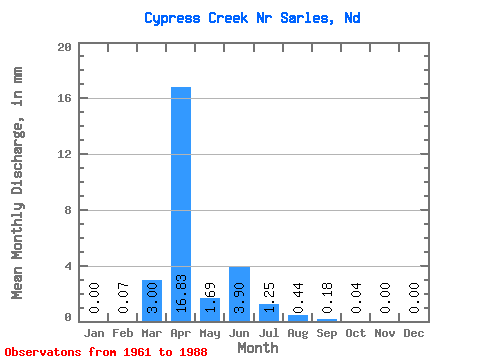
| Units: | m3/s |
| Statistic | Jan | Feb | Mar | Apr | May | Jun | Jul | Aug | Sep | Oct | Nov | Dec | Annual |
|---|---|---|---|---|---|---|---|---|---|---|---|---|---|
| Mean | 0.00 | 0.07 | 3.00 | 16.83 | 1.69 | 3.91 | 1.25 | 0.43 | 0.18 | 0.04 | 0.00 | 0.01 | 27.82 |
| Standard Deviation | 0.00 | 0.34 | 5.60 | 19.46 | 3.53 | 10.32 | 3.19 | 1.42 | 0.90 | 0.18 | 0.01 | 0.03 | 23.43 |
| Min | 0.00 | 0.00 | 0.00 | 0.01 | 0.00 | 0.00 | 0.00 | 0.00 | 0.00 | 0.00 | 0.00 | 0.00 | 1.05 |
| Max | 0.00 | 1.77 | 20.28 | 68.08 | 17.59 | 48.72 | 12.54 | 6.80 | 4.74 | 0.93 | 0.06 | 0.14 | 88.67 |
| Coefficient of Variation | 5.20 | 1.86 | 1.16 | 2.09 | 2.64 | 2.55 | 3.30 | 4.97 | 4.06 | 4.27 | 5.29 | 0.84 |
 Return to R-Arctic Net Home Page