|
|
|||||||||||||||||
| Point ID: 9645 | Downloads | Plots | Site Data | Code: 05123700 |
|
|
|||||||||||||||||
| Download | |
|---|---|
| Site Descriptor Information | Site Time Series Data |
| Link to all available data | |
| View: | Time Series | All |
| Units: | mm |
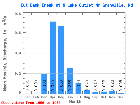
| Statistic | Jan | Feb | Mar | Apr | May | Jun | Jul | Aug | Sep | Oct | Nov | Dec | Annual |
|---|---|---|---|---|---|---|---|---|---|---|---|---|---|
| Mean | 0.00 | 0.00 | 0.20 | 0.71 | 0.67 | 0.26 | 0.10 | 0.04 | 0.02 | 0.02 | 0.02 | 0.01 | 0.18 |
| Standard Deviation | 0.00 | 0.00 | 0.75 | 1.64 | 1.24 | 0.64 | 0.20 | 0.09 | 0.04 | 0.05 | 0.05 | 0.02 | 0.30 |
| Min | 0.00 | 0.00 | 0.00 | 0.00 | 0.00 | 0.00 | 0.00 | 0.00 | 0.00 | 0.00 | 0.00 | 0.00 | 0.00 |
| Max | 0.01 | 0.00 | 3.57 | 7.53 | 4.37 | 2.90 | 0.76 | 0.37 | 0.16 | 0.19 | 0.21 | 0.09 | 1.11 |
| Coefficient of Variation | 3.18 | 4.90 | 3.80 | 2.32 | 1.85 | 2.48 | 1.98 | 2.28 | 2.49 | 2.20 | 2.32 | 2.41 | 1.69 |
 Return to R-Arctic Net Home Page