|
|
|||||||||||||||||
| Point ID: 9645 | Downloads | Plots | Site Data | Code: 05123700 |
|
|
|||||||||||||||||
| Download | |
|---|---|
| Site Descriptor Information | Site Time Series Data |
| Link to all available data | |
| View: | Time Series | All |
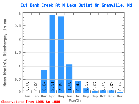
| Units: | m3/s |
| Statistic | Jan | Feb | Mar | Apr | May | Jun | Jul | Aug | Sep | Oct | Nov | Dec | Annual |
|---|---|---|---|---|---|---|---|---|---|---|---|---|---|
| Mean | 0.00 | 0.00 | 0.38 | 1.33 | 1.29 | 0.48 | 0.20 | 0.08 | 0.03 | 0.04 | 0.04 | 0.02 | 4.05 |
| Standard Deviation | 0.01 | 0.00 | 1.46 | 3.08 | 2.39 | 1.20 | 0.40 | 0.18 | 0.08 | 0.09 | 0.10 | 0.04 | 6.86 |
| Min | 0.00 | 0.00 | 0.00 | 0.00 | 0.00 | 0.00 | 0.00 | 0.00 | 0.00 | 0.00 | 0.00 | 0.00 | 0.00 |
| Max | 0.02 | 0.01 | 6.91 | 14.11 | 8.46 | 5.43 | 1.47 | 0.72 | 0.30 | 0.36 | 0.39 | 0.17 | 25.38 |
| Coefficient of Variation | 3.18 | 4.90 | 3.80 | 2.32 | 1.85 | 2.48 | 1.98 | 2.28 | 2.49 | 2.20 | 2.32 | 2.41 | 1.69 |
 Return to R-Arctic Net Home Page