|
|
|||||||||||||||||
| Point ID: 9636 | Downloads | Plots | Site Data | Code: 05076500 |
|
|
|||||||||||||||||
| Download | |
|---|---|
| Site Descriptor Information | Site Time Series Data |
| Link to all available data | |
| View: | Time Series | All |
| Units: | mm |
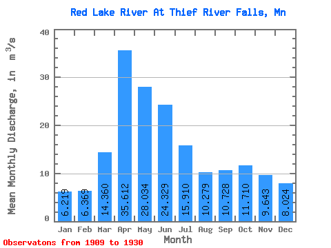
| Statistic | Jan | Feb | Mar | Apr | May | Jun | Jul | Aug | Sep | Oct | Nov | Dec | Annual |
|---|---|---|---|---|---|---|---|---|---|---|---|---|---|
| Mean | 6.22 | 6.37 | 14.36 | 35.61 | 28.03 | 24.33 | 15.91 | 10.28 | 10.73 | 11.71 | 9.64 | 8.02 | 15.10 |
| Standard Deviation | 4.18 | 4.50 | 15.62 | 27.43 | 26.48 | 16.18 | 13.23 | 8.60 | 9.51 | 7.72 | 6.29 | 5.32 | 9.66 |
| Min | 0.11 | 0.11 | 0.20 | 2.42 | 2.63 | 2.78 | 1.82 | 0.87 | 0.74 | 0.93 | 0.39 | 0.26 | 3.76 |
| Max | 15.01 | 15.01 | 62.30 | 101.38 | 106.20 | 65.76 | 53.40 | 31.30 | 36.81 | 29.44 | 23.44 | 19.82 | 40.10 |
| Coefficient of Variation | 0.67 | 0.71 | 1.09 | 0.77 | 0.94 | 0.67 | 0.83 | 0.84 | 0.89 | 0.66 | 0.65 | 0.66 | 0.64 |
 Return to R-Arctic Net Home Page