|
|
|||||||||||||||||
| Point ID: 9636 | Downloads | Plots | Site Data | Code: 05076500 |
|
|
|||||||||||||||||
| Download | |
|---|---|
| Site Descriptor Information | Site Time Series Data |
| Link to all available data | |
| View: | Time Series | All |
| Units: | m3/s |
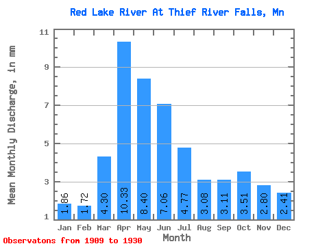
| Statistic | Jan | Feb | Mar | Apr | May | Jun | Jul | Aug | Sep | Oct | Nov | Dec | Annual |
|---|---|---|---|---|---|---|---|---|---|---|---|---|---|
| Mean | 1.86 | 1.74 | 4.30 | 10.33 | 8.40 | 7.06 | 4.77 | 3.08 | 3.11 | 3.51 | 2.80 | 2.41 | 53.34 |
| Standard Deviation | 1.25 | 1.23 | 4.68 | 7.96 | 7.94 | 4.69 | 3.97 | 2.58 | 2.76 | 2.31 | 1.83 | 1.59 | 34.11 |
| Min | 0.03 | 0.03 | 0.06 | 0.70 | 0.79 | 0.81 | 0.55 | 0.26 | 0.21 | 0.28 | 0.11 | 0.08 | 13.27 |
| Max | 4.50 | 4.10 | 18.67 | 29.41 | 31.83 | 19.08 | 16.00 | 9.38 | 10.68 | 8.82 | 6.80 | 5.94 | 141.63 |
| Coefficient of Variation | 0.67 | 0.71 | 1.09 | 0.77 | 0.94 | 0.67 | 0.83 | 0.84 | 0.89 | 0.66 | 0.65 | 0.66 | 0.64 |
 Return to R-Arctic Net Home Page