|
|
|||||||||||||||||
| Point ID: 9633 | Downloads | Plots | Site Data | Code: 05056239 |
|
|
|||||||||||||||||
| Download | |
|---|---|
| Site Descriptor Information | Site Time Series Data |
| Link to all available data | |
| View: | Time Series | All |
| Units: | mm |
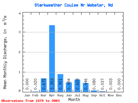
| Statistic | Jan | Feb | Mar | Apr | May | Jun | Jul | Aug | Sep | Oct | Nov | Dec | Annual |
|---|---|---|---|---|---|---|---|---|---|---|---|---|---|
| Mean | 0.00 | 0.02 | 0.68 | 3.35 | 0.90 | 0.48 | 0.63 | 0.45 | 0.08 | 0.04 | 0.00 | 0.00 | 0.26 |
| Standard Deviation | 0.00 | 0.06 | 1.19 | 3.31 | 1.80 | 0.97 | 0.93 | 0.88 | 0.17 | 0.05 | 0.01 | 0.00 | 0.20 |
| Min | 0.00 | 0.00 | 0.00 | 0.03 | 0.00 | 0.00 | 0.00 | 0.00 | 0.00 | 0.00 | 0.00 | 0.00 | 0.03 |
| Max | 0.00 | 0.19 | 5.11 | 10.11 | 8.03 | 4.58 | 3.37 | 3.92 | 0.62 | 0.16 | 0.03 | 0.00 | 0.58 |
| Coefficient of Variation | 2.97 | 1.76 | 0.99 | 2.00 | 2.02 | 1.48 | 1.96 | 2.15 | 1.37 | 2.98 | 3.00 | 0.79 |
 Return to R-Arctic Net Home Page