|
|
|||||||||||||||||
| Point ID: 9633 | Downloads | Plots | Site Data | Code: 05056239 |
|
|
|||||||||||||||||
| Download | |
|---|---|
| Site Descriptor Information | Site Time Series Data |
| Link to all available data | |
| View: | Time Series | All |
| Units: | m3/s |
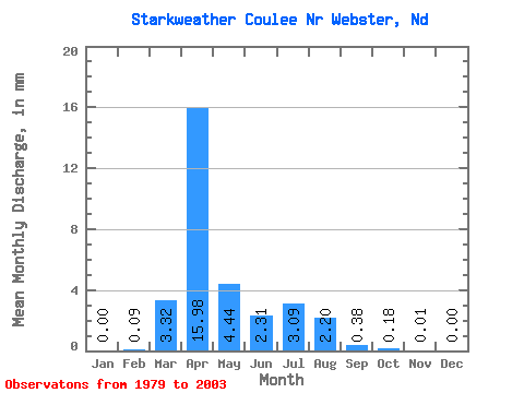
| Statistic | Jan | Feb | Mar | Apr | May | Jun | Jul | Aug | Sep | Oct | Nov | Dec | Annual |
|---|---|---|---|---|---|---|---|---|---|---|---|---|---|
| Mean | 0.00 | 0.06 | 2.25 | 10.82 | 3.01 | 1.56 | 2.09 | 1.49 | 0.26 | 0.12 | 0.01 | 0.00 | 10.18 |
| Standard Deviation | 0.00 | 0.18 | 3.97 | 10.68 | 6.02 | 3.15 | 3.10 | 2.92 | 0.55 | 0.17 | 0.03 | 0.00 | 8.02 |
| Min | 0.00 | 0.00 | 0.00 | 0.08 | 0.00 | 0.00 | 0.00 | 0.00 | 0.00 | 0.00 | 0.00 | 0.00 | 1.27 |
| Max | 0.00 | 0.57 | 17.05 | 32.64 | 26.80 | 14.80 | 11.25 | 13.07 | 2.01 | 0.52 | 0.10 | 0.01 | 22.97 |
| Coefficient of Variation | 2.97 | 1.76 | 0.99 | 2.00 | 2.02 | 1.48 | 1.96 | 2.15 | 1.37 | 2.98 | 3.00 | 0.79 |
 Return to R-Arctic Net Home Page