|
|
|||||||||||||||||
| Point ID: 9629 | Downloads | Plots | Site Data | Code: 05126000 |
|
|
|||||||||||||||||
| Download | |
|---|---|
| Site Descriptor Information | Site Time Series Data |
| Link to all available data | |
| View: | Time Series | All |
| Units: | mm |
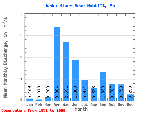
| Statistic | Jan | Feb | Mar | Apr | May | Jun | Jul | Aug | Sep | Oct | Nov | Dec | Annual |
|---|---|---|---|---|---|---|---|---|---|---|---|---|---|
| Mean | 0.11 | 0.07 | 0.20 | 3.38 | 2.69 | 1.88 | 0.97 | 0.60 | 1.33 | 0.77 | 0.75 | 0.30 | 1.08 |
| Standard Deviation | 0.06 | 0.04 | 0.16 | 1.85 | 1.72 | 0.99 | 0.83 | 0.56 | 1.11 | 0.71 | 0.53 | 0.24 | 0.28 |
| Min | 0.00 | 0.00 | 0.05 | 0.39 | 0.66 | 0.49 | 0.08 | 0.01 | 0.01 | 0.02 | 0.01 | 0.00 | 0.74 |
| Max | 0.18 | 0.13 | 0.51 | 6.88 | 7.11 | 4.07 | 3.38 | 1.62 | 3.75 | 3.10 | 1.98 | 0.93 | 1.62 |
| Coefficient of Variation | 0.51 | 0.53 | 0.82 | 0.55 | 0.64 | 0.53 | 0.85 | 0.93 | 0.83 | 0.93 | 0.71 | 0.79 | 0.26 |
 Return to R-Arctic Net Home Page