|
|
|||||||||||||||||
| Point ID: 9629 | Downloads | Plots | Site Data | Code: 05126000 |
|
|
|||||||||||||||||
| Download | |
|---|---|
| Site Descriptor Information | Site Time Series Data |
| Link to all available data | |
| View: | Time Series | All |
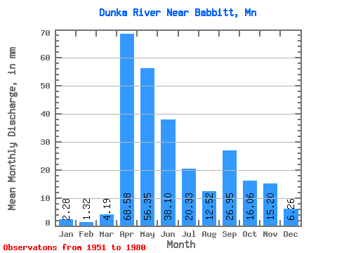
| Units: | m3/s |
| Statistic | Jan | Feb | Mar | Apr | May | Jun | Jul | Aug | Sep | Oct | Nov | Dec | Annual |
|---|---|---|---|---|---|---|---|---|---|---|---|---|---|
| Mean | 2.10 | 1.24 | 3.88 | 63.42 | 52.10 | 35.23 | 18.81 | 11.57 | 24.93 | 14.85 | 14.05 | 5.79 | 246.29 |
| Standard Deviation | 1.07 | 0.66 | 3.17 | 34.67 | 33.35 | 18.60 | 16.09 | 10.77 | 20.82 | 13.73 | 9.95 | 4.57 | 63.02 |
| Min | 0.00 | 0.00 | 0.93 | 7.39 | 12.84 | 9.19 | 1.57 | 0.15 | 0.15 | 0.38 | 0.18 | 0.00 | 168.90 |
| Max | 3.43 | 2.35 | 9.87 | 128.96 | 137.74 | 76.23 | 65.55 | 31.37 | 70.20 | 60.09 | 37.10 | 18.08 | 368.73 |
| Coefficient of Variation | 0.51 | 0.53 | 0.82 | 0.55 | 0.64 | 0.53 | 0.85 | 0.93 | 0.83 | 0.93 | 0.71 | 0.79 | 0.26 |
 Return to R-Arctic Net Home Page