|
|
|||||||||||||||||
| Point ID: 9620 | Downloads | Plots | Site Data | Code: 05092200 |
|
|
|||||||||||||||||
| Download | |
|---|---|
| Site Descriptor Information | Site Time Series Data |
| Link to all available data | |
| View: | Time Series | All |
| Units: | mm |
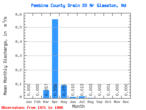
| Statistic | Jan | Feb | Mar | Apr | May | Jun | Jul | Aug | Sep | Oct | Nov | Dec | Annual |
|---|---|---|---|---|---|---|---|---|---|---|---|---|---|
| Mean | 0.00 | 0.00 | 0.06 | 0.56 | 0.09 | 0.01 | 0.01 | 0.00 | 0.00 | 0.00 | 0.00 | 0.00 | 0.07 |
| Standard Deviation | 0.00 | 0.00 | 0.07 | 0.92 | 0.28 | 0.02 | 0.04 | 0.01 | 0.01 | 0.00 | 0.00 | 0.00 | 0.10 |
| Min | 0.00 | 0.00 | 0.00 | 0.00 | 0.00 | 0.00 | 0.00 | 0.00 | 0.00 | 0.00 | 0.00 | 0.00 | 0.00 |
| Max | 0.00 | 0.00 | 0.22 | 3.51 | 1.08 | 0.07 | 0.17 | 0.04 | 0.02 | 0.01 | 0.00 | 0.00 | 0.30 |
| Coefficient of Variation | 1.26 | 1.66 | 3.03 | 1.73 | 3.55 | 3.15 | 2.28 | 2.41 | 3.32 | 1.51 |
 Return to R-Arctic Net Home Page