|
|
|||||||||||||||||
| Point ID: 9620 | Downloads | Plots | Site Data | Code: 05092200 |
|
|
|||||||||||||||||
| Download | |
|---|---|
| Site Descriptor Information | Site Time Series Data |
| Link to all available data | |
| View: | Time Series | All |
| Units: | m3/s |
| Statistic | Jan | Feb | Mar | Apr | May | Jun | Jul | Aug | Sep | Oct | Nov | Dec | Annual |
|---|---|---|---|---|---|---|---|---|---|---|---|---|---|
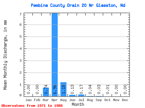
| Mean | 0.00 | 0.00 | 0.74 | 6.95 | 1.18 | 0.13 | 0.16 | 0.04 | 0.03 | 0.01 | 0.00 | 0.00 | 10.18 |
| Standard Deviation | 0.00 | 0.00 | 0.93 | 11.52 | 3.56 | 0.23 | 0.58 | 0.12 | 0.07 | 0.03 | 0.01 | 0.00 | 15.40 |
| Min | 0.00 | 0.00 | 0.00 | 0.00 | 0.00 | 0.00 | 0.00 | 0.00 | 0.00 | 0.00 | 0.00 | 0.00 | 0.04 |
| Max | 0.00 | 0.00 | 2.90 | 43.87 | 13.94 | 0.84 | 2.26 | 0.46 | 0.24 | 0.08 | 0.04 | 0.00 | 46.19 |
| Coefficient of Variation | 1.26 | 1.66 | 3.03 | 1.73 | 3.55 | 3.15 | 2.28 | 2.41 | 3.32 | 1.51 |
 Return to R-Arctic Net Home Page