|
|
|||||||||||||||||
| Point ID: 9608 | Downloads | Plots | Site Data | Code: 05059310 |
|
|
|||||||||||||||||
| Download | |
|---|---|
| Site Descriptor Information | Site Time Series Data |
| Link to all available data | |
| View: | Time Series | All |
| Units: | mm |
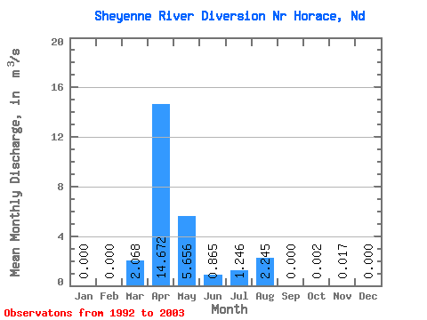
| Statistic | Jan | Feb | Mar | Apr | May | Jun | Jul | Aug | Sep | Oct | Nov | Dec | Annual |
|---|---|---|---|---|---|---|---|---|---|---|---|---|---|
| Mean | 0.00 | 0.00 | 2.07 | 14.67 | 5.66 | 0.86 | 1.25 | 2.25 | 0.00 | 0.00 | 0.02 | 0.00 | 2.45 |
| Standard Deviation | 0.00 | 0.00 | 3.94 | 16.38 | 10.94 | 1.35 | 2.44 | 7.45 | 0.00 | 0.01 | 0.06 | 0.00 | 2.16 |
| Min | 0.00 | 0.00 | 0.00 | 0.00 | 0.00 | 0.00 | 0.00 | 0.00 | 0.00 | 0.00 | 0.00 | 0.00 | 0.00 |
| Max | 0.00 | 0.00 | 13.33 | 42.68 | 33.44 | 3.94 | 7.95 | 24.70 | 0.00 | 0.02 | 0.18 | 0.00 | 6.40 |
| Coefficient of Variation | 1.91 | 1.12 | 1.93 | 1.56 | 1.96 | 3.32 | 3.32 | 3.32 | 0.88 |
 Return to R-Arctic Net Home Page