|
|
| Point ID: 9608 | Downloads | Plots | Site Data | Code: 05059310 |
|
| Download | |
|---|---|
| Site Descriptor Information | Site Time Series Data |
| Link to all available data | |
|
|
|
| View: | Statistics | All |
| Units: | mm |
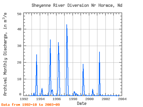
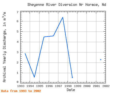
| Year | Jan | Feb | Mar | Apr | May | Jun | Jul | Aug | Sep | Oct | Nov | Dec | Annual | 1992 | 0.00 | 0.00 | 0.00 | 1993 | 0.00 | 0.00 | 0.14 | 1.56 | 0.00 | 0.00 | 7.95 | 24.70 | 0.00 | 0.00 | 0.00 | 0.00 | 2.86 | 1994 | 0.00 | 0.00 | 1.74 | 4.42 | 0.00 | 0.00 | 0.29 | 0.00 | 0.00 | 0.02 | 0.18 | 0.00 | 0.55 | 1995 | 0.00 | 0.00 | 13.33 | 33.62 | 0.67 | 2.85 | 3.42 | 0.00 | 0.00 | 0.00 | 0.00 | 0.00 | 4.49 | 1996 | 0.00 | 0.00 | 3.81 | 32.00 | 19.15 | 0.00 | 0.00 | 0.00 | 0.00 | 0.00 | 0.00 | 0.00 | 4.58 | 1997 | 0.00 | 0.00 | 0.00 | 42.68 | 33.44 | 0.47 | 0.18 | 0.00 | 0.00 | 0.00 | 0.00 | 0.00 | 6.40 | 1998 | 0.00 | 0.00 | 2.44 | 1.92 | 0.06 | 1.23 | 0.74 | 0.00 | 0.00 | 0.00 | 0.00 | 0.00 | 0.53 | 1999 | 0.00 | 0.00 | 1.17 | 18.95 | 7.92 | 1.02 | 0.00 | 0.00 | 0.00 | 0.00 | 0.00 | 0.00 | 2.42 | 2000 | 0.00 | 0.00 | 0.00 | 0.00 | 0.00 | 3.94 | 1.13 | 0.00 | 0.00 | 0.00 | 0.00 | 0.00 | 0.42 | 2001 | 0.00 | 0.00 | 0.13 | 26.24 | 0.98 | 0.00 | 0.00 | 0.00 | 0.00 | 0.00 | 0.00 | 0.00 | 2.28 | 2002 | 0.00 | 0.00 | 0.00 | 0.00 | 0.00 | 0.00 | 0.00 | 0.00 | 0.00 | 0.00 | 0.00 | 0.00 | 0.00 | 2003 | 0.00 | 0.00 | 0.00 | 0.00 | 0.00 | 0.00 | 0.00 | 0.00 | 0.00 |
|---|
 Return to R-Arctic Net Home Page