|
|
|||||||||||||||||
| Point ID: 9603 | Downloads | Plots | Site Data | Code: 05127230 |
|
|
|||||||||||||||||
| Download | |
|---|---|
| Site Descriptor Information | Site Time Series Data |
| Link to all available data | |
| View: | Time Series | All |
| Units: | mm |
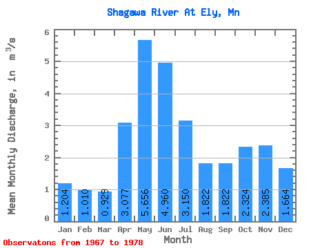
| Statistic | Jan | Feb | Mar | Apr | May | Jun | Jul | Aug | Sep | Oct | Nov | Dec | Annual |
|---|---|---|---|---|---|---|---|---|---|---|---|---|---|
| Mean | 1.20 | 1.01 | 0.93 | 3.08 | 5.66 | 4.96 | 3.15 | 1.82 | 1.82 | 2.32 | 2.38 | 1.66 | 2.58 |
| Standard Deviation | 0.75 | 0.61 | 0.42 | 1.71 | 2.45 | 2.85 | 1.34 | 1.10 | 1.94 | 2.48 | 2.12 | 1.32 | 0.73 |
| Min | 0.06 | 0.07 | 0.17 | 0.26 | 0.61 | 1.84 | 1.69 | 0.61 | 0.05 | 0.01 | 0.01 | 0.03 | 1.19 |
| Max | 2.09 | 1.95 | 1.50 | 5.90 | 9.17 | 11.31 | 6.09 | 4.62 | 6.93 | 7.65 | 5.74 | 3.77 | 3.85 |
| Coefficient of Variation | 0.62 | 0.60 | 0.46 | 0.56 | 0.43 | 0.57 | 0.43 | 0.60 | 1.06 | 1.07 | 0.89 | 0.79 | 0.28 |
 Return to R-Arctic Net Home Page