|
|
|||||||||||||||||
| Point ID: 9603 | Downloads | Plots | Site Data | Code: 05127230 |
|
|
|||||||||||||||||
| Download | |
|---|---|
| Site Descriptor Information | Site Time Series Data |
| Link to all available data | |
| View: | Time Series | All |
| Units: | m3/s |
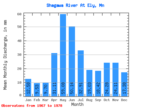
| Statistic | Jan | Feb | Mar | Apr | May | Jun | Jul | Aug | Sep | Oct | Nov | Dec | Annual |
|---|---|---|---|---|---|---|---|---|---|---|---|---|---|
| Mean | 12.57 | 9.61 | 9.70 | 31.11 | 59.07 | 50.14 | 32.90 | 19.03 | 18.42 | 24.27 | 24.11 | 17.38 | 317.76 |
| Standard Deviation | 7.85 | 5.79 | 4.43 | 17.29 | 25.56 | 28.79 | 14.03 | 11.52 | 19.61 | 25.89 | 21.47 | 13.80 | 90.24 |
| Min | 0.62 | 0.72 | 1.77 | 2.67 | 6.32 | 18.63 | 17.67 | 6.33 | 0.54 | 0.09 | 0.08 | 0.33 | 146.80 |
| Max | 21.86 | 18.59 | 15.67 | 59.67 | 95.81 | 114.39 | 63.63 | 48.24 | 70.05 | 79.94 | 58.01 | 39.35 | 474.08 |
| Coefficient of Variation | 0.62 | 0.60 | 0.46 | 0.56 | 0.43 | 0.57 | 0.43 | 0.60 | 1.06 | 1.07 | 0.89 | 0.79 | 0.28 |
 Return to R-Arctic Net Home Page