|
|
|||||||||||||||||
| Point ID: 9596 | Downloads | Plots | Site Data | Code: 05088000 |
|
|
|||||||||||||||||
| Download | |
|---|---|
| Site Descriptor Information | Site Time Series Data |
| Link to all available data | |
| View: | Time Series | All |
| Units: | mm |
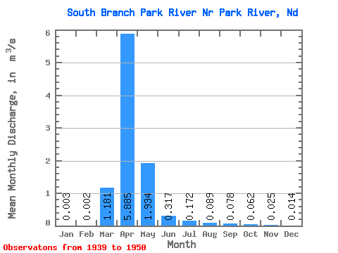
| Statistic | Jan | Feb | Mar | Apr | May | Jun | Jul | Aug | Sep | Oct | Nov | Dec | Annual |
|---|---|---|---|---|---|---|---|---|---|---|---|---|---|
| Mean | 0.00 | 0.00 | 1.18 | 5.88 | 1.93 | 0.32 | 0.17 | 0.09 | 0.08 | 0.06 | 0.03 | 0.01 | 0.59 |
| Standard Deviation | 0.00 | 0.00 | 1.69 | 6.45 | 5.37 | 0.45 | 0.25 | 0.18 | 0.15 | 0.16 | 0.04 | 0.02 | 0.45 |
| Min | 0.00 | 0.00 | 0.00 | 0.50 | 0.07 | 0.01 | 0.00 | 0.00 | 0.00 | 0.00 | 0.00 | 0.00 | 0.05 |
| Max | 0.01 | 0.01 | 5.12 | 18.17 | 18.10 | 1.59 | 0.68 | 0.61 | 0.49 | 0.55 | 0.11 | 0.08 | 1.60 |
| Coefficient of Variation | 1.04 | 1.08 | 1.43 | 1.09 | 2.78 | 1.42 | 1.48 | 2.04 | 1.89 | 2.63 | 1.64 | 1.75 | 0.76 |
 Return to R-Arctic Net Home Page