|
|
|||||||||||||||||
| Point ID: 9596 | Downloads | Plots | Site Data | Code: 05088000 |
|
|
|||||||||||||||||
| Download | |
|---|---|
| Site Descriptor Information | Site Time Series Data |
| Link to all available data | |
| View: | Time Series | All |
| Units: | m3/s |
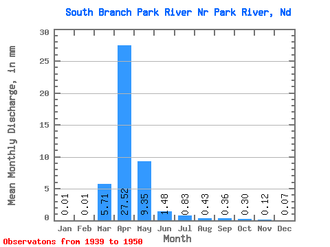
| Statistic | Jan | Feb | Mar | Apr | May | Jun | Jul | Aug | Sep | Oct | Nov | Dec | Annual |
|---|---|---|---|---|---|---|---|---|---|---|---|---|---|
| Mean | 0.01 | 0.01 | 5.71 | 27.52 | 9.34 | 1.48 | 0.83 | 0.43 | 0.37 | 0.30 | 0.12 | 0.07 | 33.44 |
| Standard Deviation | 0.01 | 0.01 | 8.17 | 30.14 | 25.96 | 2.11 | 1.23 | 0.87 | 0.69 | 0.79 | 0.19 | 0.12 | 25.55 |
| Min | 0.00 | 0.00 | 0.00 | 2.34 | 0.31 | 0.02 | 0.01 | 0.01 | 0.00 | 0.00 | 0.00 | 0.00 | 2.73 |
| Max | 0.04 | 0.03 | 24.76 | 84.99 | 87.45 | 7.44 | 3.26 | 2.97 | 2.31 | 2.68 | 0.50 | 0.38 | 91.28 |
| Coefficient of Variation | 1.04 | 1.08 | 1.43 | 1.09 | 2.78 | 1.42 | 1.48 | 2.04 | 1.89 | 2.63 | 1.64 | 1.75 | 0.76 |
 Return to R-Arctic Net Home Page