|
|
|||||||||||||||||
| Point ID: 9590 | Downloads | Plots | Site Data | Code: 05083500 |
|
|
|||||||||||||||||
| Download | |
|---|---|
| Site Descriptor Information | Site Time Series Data |
| Link to all available data | |
| View: | Time Series | All |
| Units: | mm |
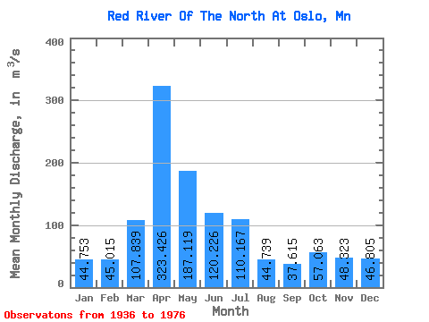
| Statistic | Jan | Feb | Mar | Apr | May | Jun | Jul | Aug | Sep | Oct | Nov | Dec | Annual |
|---|---|---|---|---|---|---|---|---|---|---|---|---|---|
| Mean | 44.75 | 45.02 | 107.84 | 323.43 | 187.12 | 120.23 | 110.17 | 44.74 | 37.62 | 57.06 | 48.32 | 46.80 | 161.47 |
| Standard Deviation | 6.91 | 3.92 | 161.96 | 227.45 | 237.56 | 86.38 | 143.66 | 27.70 | 23.43 | 43.82 | 32.40 | 10.41 | 42.49 |
| Min | 36.78 | 40.51 | 18.19 | 43.07 | 40.58 | 8.11 | 2.63 | 0.88 | 0.54 | 0.39 | 0.34 | 35.12 | 131.42 |
| Max | 49.14 | 47.71 | 634.93 | 865.36 | 1159.35 | 332.85 | 724.55 | 89.78 | 74.97 | 106.69 | 69.19 | 55.08 | 191.51 |
| Coefficient of Variation | 0.15 | 0.09 | 1.50 | 0.70 | 1.27 | 0.72 | 1.30 | 0.62 | 0.62 | 0.77 | 0.67 | 0.22 | 0.26 |
 Return to R-Arctic Net Home Page