|
|
|||||||||||||||||
| Point ID: 9590 | Downloads | Plots | Site Data | Code: 05083500 |
|
|
|||||||||||||||||
| Download | |
|---|---|
| Site Descriptor Information | Site Time Series Data |
| Link to all available data | |
| View: | Time Series | All |
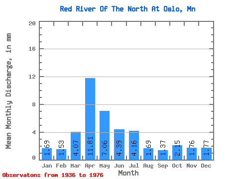
| Units: | m3/s |
| Statistic | Jan | Feb | Mar | Apr | May | Jun | Jul | Aug | Sep | Oct | Nov | Dec | Annual |
|---|---|---|---|---|---|---|---|---|---|---|---|---|---|
| Mean | 1.48 | 1.36 | 3.57 | 10.37 | 6.20 | 3.86 | 3.65 | 1.48 | 1.21 | 1.89 | 1.55 | 1.55 | 63.06 |
| Standard Deviation | 0.23 | 0.12 | 5.37 | 7.30 | 7.87 | 2.77 | 4.76 | 0.92 | 0.75 | 1.45 | 1.04 | 0.34 | 16.59 |
| Min | 1.22 | 1.22 | 0.60 | 1.38 | 1.34 | 0.26 | 0.09 | 0.03 | 0.02 | 0.01 | 0.01 | 1.16 | 51.33 |
| Max | 1.63 | 1.44 | 21.04 | 27.76 | 38.42 | 10.68 | 24.01 | 2.98 | 2.41 | 3.54 | 2.22 | 1.82 | 74.80 |
| Coefficient of Variation | 0.15 | 0.09 | 1.50 | 0.70 | 1.27 | 0.72 | 1.30 | 0.62 | 0.62 | 0.77 | 0.67 | 0.22 | 0.26 |
 Return to R-Arctic Net Home Page