|
|
|||||||||||||||||
| Point ID: 9588 | Downloads | Plots | Site Data | Code: 05084500 |
|
|
|||||||||||||||||
| Download | |
|---|---|
| Site Descriptor Information | Site Time Series Data |
| Link to all available data | |
| View: | Time Series | All |
| Units: | mm |
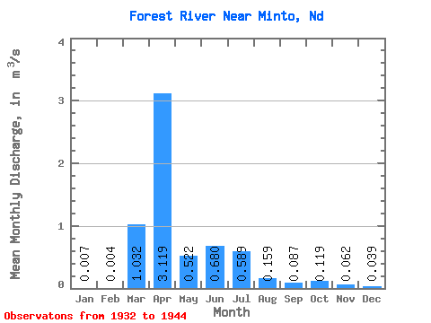
| Statistic | Jan | Feb | Mar | Apr | May | Jun | Jul | Aug | Sep | Oct | Nov | Dec | Annual |
|---|---|---|---|---|---|---|---|---|---|---|---|---|---|
| Mean | 0.01 | 0.00 | 1.03 | 3.12 | 0.52 | 0.68 | 0.59 | 0.16 | 0.09 | 0.12 | 0.06 | 0.04 | 0.61 |
| Standard Deviation | 0.01 | 0.01 | 1.54 | 3.26 | 0.26 | 1.45 | 1.52 | 0.22 | 0.12 | 0.28 | 0.11 | 0.07 | 0.63 |
| Min | 0.00 | 0.00 | 0.00 | 0.31 | 0.20 | 0.05 | 0.00 | 0.00 | 0.00 | 0.00 | 0.00 | 0.00 | 0.07 |
| Max | 0.04 | 0.03 | 4.05 | 10.06 | 1.10 | 5.45 | 5.16 | 0.57 | 0.27 | 0.91 | 0.32 | 0.17 | 1.61 |
| Coefficient of Variation | 1.77 | 2.91 | 1.50 | 1.04 | 0.50 | 2.13 | 2.58 | 1.36 | 1.33 | 2.36 | 1.76 | 1.67 | 1.03 |
 Return to R-Arctic Net Home Page