|
|
|||||||||||||||||
| Point ID: 9588 | Downloads | Plots | Site Data | Code: 05084500 |
|
|
|||||||||||||||||
| Download | |
|---|---|
| Site Descriptor Information | Site Time Series Data |
| Link to all available data | |
| View: | Time Series | All |
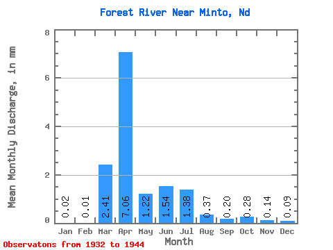
| Units: | m3/s |
| Statistic | Jan | Feb | Mar | Apr | May | Jun | Jul | Aug | Sep | Oct | Nov | Dec | Annual |
|---|---|---|---|---|---|---|---|---|---|---|---|---|---|
| Mean | 0.01 | 0.01 | 1.85 | 5.40 | 0.94 | 1.18 | 1.05 | 0.28 | 0.15 | 0.21 | 0.11 | 0.07 | 12.95 |
| Standard Deviation | 0.02 | 0.02 | 2.76 | 5.64 | 0.47 | 2.50 | 2.72 | 0.39 | 0.20 | 0.50 | 0.19 | 0.12 | 13.29 |
| Min | 0.00 | 0.00 | 0.00 | 0.54 | 0.35 | 0.08 | 0.00 | 0.00 | 0.00 | 0.00 | 0.00 | 0.00 | 1.56 |
| Max | 0.07 | 0.05 | 7.25 | 17.43 | 1.97 | 9.43 | 9.22 | 1.03 | 0.47 | 1.63 | 0.55 | 0.30 | 34.05 |
| Coefficient of Variation | 1.77 | 2.91 | 1.50 | 1.04 | 0.50 | 2.13 | 2.58 | 1.36 | 1.33 | 2.36 | 1.76 | 1.67 | 1.03 |
 Return to R-Arctic Net Home Page