|
|
|||||||||||||||||
| Point ID: 9585 | Downloads | Plots | Site Data | Code: 05051000 |
|
|
|||||||||||||||||
| Download | |
|---|---|
| Site Descriptor Information | Site Time Series Data |
| Link to all available data | |
| View: | Time Series | All |
| Units: | mm |
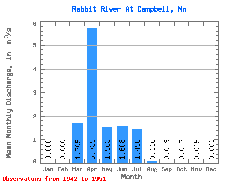
| Statistic | Jan | Feb | Mar | Apr | May | Jun | Jul | Aug | Sep | Oct | Nov | Dec | Annual |
|---|---|---|---|---|---|---|---|---|---|---|---|---|---|
| Mean | 0.00 | 0.00 | 1.71 | 5.74 | 1.56 | 1.61 | 1.46 | 0.12 | 0.02 | 0.02 | 0.01 | 0.00 | 0.99 |
| Standard Deviation | 0.00 | 0.00 | 1.98 | 5.55 | 2.86 | 3.03 | 3.06 | 0.24 | 0.04 | 0.02 | 0.02 | 0.00 | 0.43 |
| Min | 0.00 | 0.00 | 0.13 | 0.40 | 0.01 | 0.00 | 0.01 | 0.00 | 0.00 | 0.00 | 0.00 | 0.00 | 0.46 |
| Max | 0.00 | 0.00 | 5.34 | 13.80 | 7.91 | 9.16 | 9.49 | 0.68 | 0.13 | 0.04 | 0.06 | 0.01 | 1.59 |
| Coefficient of Variation | 1.16 | 0.97 | 1.83 | 1.89 | 2.10 | 2.03 | 2.27 | 1.02 | 1.29 | 1.85 | 0.44 |
 Return to R-Arctic Net Home Page