|
|
|||||||||||||||||
| Point ID: 9585 | Downloads | Plots | Site Data | Code: 05051000 |
|
|
|||||||||||||||||
| Download | |
|---|---|
| Site Descriptor Information | Site Time Series Data |
| Link to all available data | |
| View: | Time Series | All |
| Units: | m3/s |
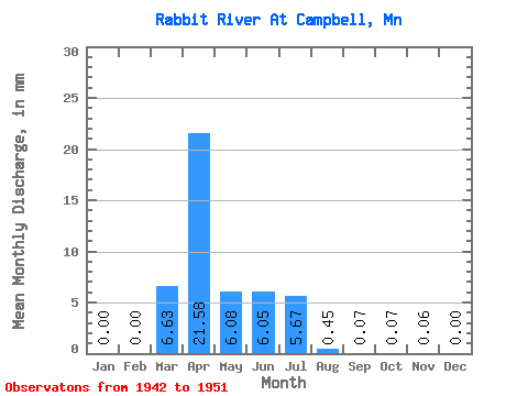
| Statistic | Jan | Feb | Mar | Apr | May | Jun | Jul | Aug | Sep | Oct | Nov | Dec | Annual |
|---|---|---|---|---|---|---|---|---|---|---|---|---|---|
| Mean | 0.00 | 0.00 | 6.63 | 21.58 | 6.08 | 6.05 | 5.67 | 0.45 | 0.07 | 0.07 | 0.06 | 0.01 | 45.42 |
| Standard Deviation | 0.00 | 0.00 | 7.71 | 20.89 | 11.13 | 11.41 | 11.91 | 0.92 | 0.16 | 0.07 | 0.07 | 0.01 | 19.88 |
| Min | 0.00 | 0.00 | 0.50 | 1.52 | 0.02 | 0.00 | 0.02 | 0.00 | 0.00 | 0.00 | 0.00 | 0.00 | 21.09 |
| Max | 0.00 | 0.00 | 20.75 | 51.94 | 30.73 | 34.48 | 36.88 | 2.65 | 0.50 | 0.17 | 0.23 | 0.03 | 73.03 |
| Coefficient of Variation | 1.16 | 0.97 | 1.83 | 1.89 | 2.10 | 2.03 | 2.27 | 1.02 | 1.29 | 1.85 | 0.44 |
 Return to R-Arctic Net Home Page