|
|
|||||||||||||||||
| Point ID: 9561 | Downloads | Plots | Site Data | Code: 05056340 |
|
|
|||||||||||||||||
| Download | |
|---|---|
| Site Descriptor Information | Site Time Series Data |
| Link to all available data | |
| View: | Time Series | All |
| Units: | mm |
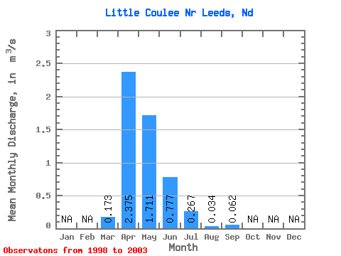
| Statistic | Jan | Feb | Mar | Apr | May | Jun | Jul | Aug | Sep | Oct | Nov | Dec | Annual |
|---|---|---|---|---|---|---|---|---|---|---|---|---|---|
| Mean | 0.17 | 2.38 | 1.71 | 0.78 | 0.27 | 0.03 | 0.06 | ||||||
| Standard Deviation | 0.27 | 2.60 | 2.25 | 1.21 | 0.31 | 0.07 | 0.10 | ||||||
| Min | 0.00 | 0.00 | 0.00 | 0.00 | 0.00 | 0.00 | 0.00 | ||||||
| Max | 0.70 | 6.15 | 5.87 | 3.11 | 0.80 | 0.18 | 0.24 | ||||||
| Coefficient of Variation | 1.57 | 1.09 | 1.32 | 1.55 | 1.16 | 2.13 | 1.64 |
 Return to R-Arctic Net Home Page