|
|
|||||||||||||||||
| Point ID: 9561 | Downloads | Plots | Site Data | Code: 05056340 |
|
|
|||||||||||||||||
| Download | |
|---|---|
| Site Descriptor Information | Site Time Series Data |
| Link to all available data | |
| View: | Time Series | All |
| Units: | m3/s |
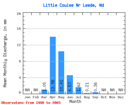
| Statistic | Jan | Feb | Mar | Apr | May | Jun | Jul | Aug | Sep | Oct | Nov | Dec | Annual |
|---|---|---|---|---|---|---|---|---|---|---|---|---|---|
| Mean | 0.56 | 7.43 | 5.53 | 2.43 | 0.86 | 0.11 | 0.19 | ||||||
| Standard Deviation | 0.88 | 8.13 | 7.28 | 3.78 | 1.00 | 0.24 | 0.32 | ||||||
| Min | 0.00 | 0.00 | 0.00 | 0.00 | 0.01 | 0.00 | 0.00 | ||||||
| Max | 2.27 | 19.25 | 18.95 | 9.72 | 2.58 | 0.60 | 0.74 | ||||||
| Coefficient of Variation | 1.57 | 1.09 | 1.32 | 1.55 | 1.16 | 2.13 | 1.64 |
 Return to R-Arctic Net Home Page