|
|
|||||||||||||||||
| Point ID: 9517 | Downloads | Plots | Site Data | Code: 15290000 |
|
|
|||||||||||||||||
| Download | |
|---|---|
| Site Descriptor Information | Site Time Series Data |
| Link to all available data | |
| View: | Time Series | All |
| Units: | mm |
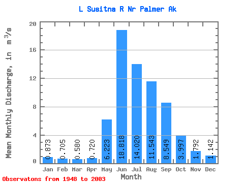
| Statistic | Jan | Feb | Mar | Apr | May | Jun | Jul | Aug | Sep | Oct | Nov | Dec | Annual |
|---|---|---|---|---|---|---|---|---|---|---|---|---|---|
| Mean | 0.87 | 0.70 | 0.58 | 0.72 | 6.22 | 18.82 | 14.02 | 11.54 | 8.55 | 4.00 | 1.79 | 1.14 | 5.75 |
| Standard Deviation | 0.18 | 0.15 | 0.13 | 0.25 | 3.48 | 6.14 | 5.74 | 4.86 | 4.05 | 1.97 | 0.55 | 0.25 | 1.35 |
| Min | 0.49 | 0.40 | 0.28 | 0.28 | 1.50 | 7.80 | 5.45 | 4.79 | 2.33 | 1.45 | 0.69 | 0.49 | 2.84 |
| Max | 1.53 | 1.17 | 0.84 | 1.93 | 18.38 | 34.41 | 29.66 | 25.73 | 18.44 | 11.08 | 3.80 | 1.75 | 8.84 |
| Coefficient of Variation | 0.20 | 0.22 | 0.23 | 0.35 | 0.56 | 0.33 | 0.41 | 0.42 | 0.47 | 0.49 | 0.30 | 0.21 | 0.24 |
 Return to R-Arctic Net Home Page