|
|
|||||||||||||||||
| Point ID: 9517 | Downloads | Plots | Site Data | Code: 15290000 |
|
|
|||||||||||||||||
| Download | |
|---|---|
| Site Descriptor Information | Site Time Series Data |
| Link to all available data | |
| View: | Time Series | All |
| Units: | m3/s |
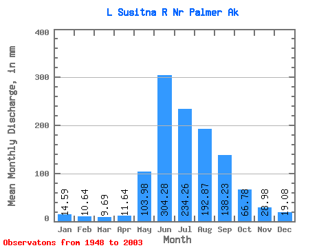
| Statistic | Jan | Feb | Mar | Apr | May | Jun | Jul | Aug | Sep | Oct | Nov | Dec | Annual |
|---|---|---|---|---|---|---|---|---|---|---|---|---|---|
| Mean | 14.59 | 10.73 | 9.69 | 11.64 | 103.97 | 304.29 | 234.22 | 192.83 | 138.24 | 66.78 | 28.97 | 19.08 | 1131.38 |
| Standard Deviation | 2.94 | 2.35 | 2.18 | 4.06 | 58.23 | 99.35 | 95.95 | 81.20 | 65.46 | 32.84 | 8.83 | 4.11 | 266.63 |
| Min | 8.26 | 6.03 | 4.73 | 4.58 | 25.03 | 126.14 | 91.11 | 80.07 | 37.62 | 24.25 | 11.20 | 8.24 | 558.93 |
| Max | 25.59 | 17.78 | 14.07 | 31.12 | 306.97 | 556.33 | 495.49 | 429.81 | 298.21 | 185.14 | 61.41 | 29.18 | 1740.47 |
| Coefficient of Variation | 0.20 | 0.22 | 0.23 | 0.35 | 0.56 | 0.33 | 0.41 | 0.42 | 0.47 | 0.49 | 0.30 | 0.21 | 0.24 |
 Return to R-Arctic Net Home Page