|
|
|||||||||||||||||
| Point ID: 9501 | Downloads | Plots | Site Data | Code: 15297200 |
|
|
|||||||||||||||||
| Download | |
|---|---|
| Site Descriptor Information | Site Time Series Data |
| Link to all available data | |
| View: | Time Series | All |
| Units: | mm |
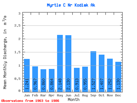
| Statistic | Jan | Feb | Mar | Apr | May | Jun | Jul | Aug | Sep | Oct | Nov | Dec | Annual |
|---|---|---|---|---|---|---|---|---|---|---|---|---|---|
| Mean | 1.24 | 0.97 | 0.86 | 0.86 | 2.15 | 2.13 | 0.91 | 0.95 | 1.53 | 1.41 | 1.25 | 1.13 | 1.30 |
| Standard Deviation | 0.99 | 0.78 | 0.85 | 0.43 | 0.82 | 1.05 | 0.58 | 0.72 | 0.70 | 0.72 | 0.61 | 1.03 | 0.20 |
| Min | 0.04 | 0.06 | 0.04 | 0.10 | 0.43 | 0.42 | 0.22 | 0.12 | 0.31 | 0.56 | 0.31 | 0.09 | 1.03 |
| Max | 3.49 | 2.24 | 3.07 | 1.73 | 4.05 | 4.96 | 2.47 | 2.99 | 3.02 | 3.41 | 2.88 | 3.75 | 1.75 |
| Coefficient of Variation | 0.80 | 0.81 | 0.99 | 0.50 | 0.38 | 0.49 | 0.64 | 0.75 | 0.46 | 0.51 | 0.49 | 0.91 | 0.15 |
 Return to R-Arctic Net Home Page