|
|
|||||||||||||||||
| Point ID: 9501 | Downloads | Plots | Site Data | Code: 15297200 |
|
|
|||||||||||||||||
| Download | |
|---|---|
| Site Descriptor Information | Site Time Series Data |
| Link to all available data | |
| View: | Time Series | All |
| Units: | m3/s |
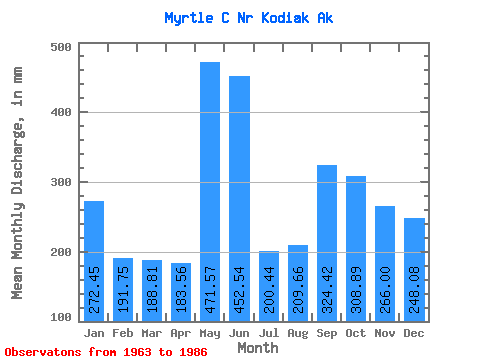
| Statistic | Jan | Feb | Mar | Apr | May | Jun | Jul | Aug | Sep | Oct | Nov | Dec | Annual |
|---|---|---|---|---|---|---|---|---|---|---|---|---|---|
| Mean | 272.37 | 193.42 | 188.81 | 183.57 | 471.61 | 452.45 | 200.37 | 209.70 | 324.45 | 308.78 | 266.10 | 248.11 | 3374.69 |
| Standard Deviation | 217.21 | 155.70 | 187.55 | 91.84 | 181.11 | 223.63 | 128.45 | 157.47 | 149.84 | 158.12 | 130.36 | 226.38 | 508.07 |
| Min | 9.33 | 12.87 | 7.63 | 20.32 | 94.45 | 90.22 | 48.29 | 25.65 | 66.43 | 123.22 | 66.48 | 19.01 | 2662.18 |
| Max | 765.34 | 448.29 | 673.31 | 368.62 | 890.05 | 1053.82 | 543.06 | 656.67 | 641.54 | 747.68 | 611.66 | 823.89 | 4539.39 |
| Coefficient of Variation | 0.80 | 0.81 | 0.99 | 0.50 | 0.38 | 0.49 | 0.64 | 0.75 | 0.46 | 0.51 | 0.49 | 0.91 | 0.15 |
 Return to R-Arctic Net Home Page