|
|
|||||||||||||||||
| Point ID: 9483 | Downloads | Plots | Site Data | Code: 15294500 |
|
|
|||||||||||||||||
| Download | |
|---|---|
| Site Descriptor Information | Site Time Series Data |
| Link to all available data | |
| View: | Time Series | All |
| Units: | mm |
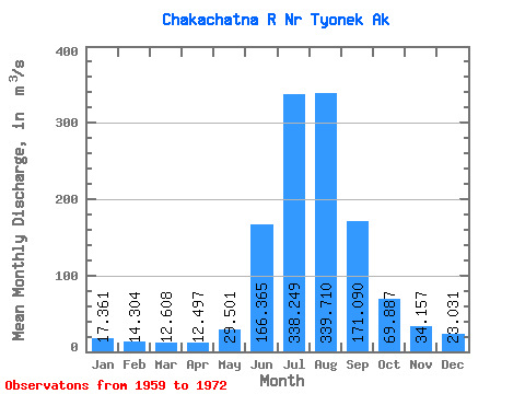
| Statistic | Jan | Feb | Mar | Apr | May | Jun | Jul | Aug | Sep | Oct | Nov | Dec | Annual |
|---|---|---|---|---|---|---|---|---|---|---|---|---|---|
| Mean | 17.36 | 14.30 | 12.61 | 12.50 | 29.50 | 166.37 | 338.25 | 339.71 | 171.09 | 69.89 | 34.16 | 23.03 | 102.47 |
| Standard Deviation | 2.55 | 3.15 | 2.22 | 3.55 | 15.45 | 57.91 | 44.84 | 68.40 | 53.51 | 23.79 | 7.26 | 3.44 | 12.86 |
| Min | 13.59 | 10.78 | 9.20 | 7.08 | 13.34 | 59.87 | 282.03 | 238.32 | 94.79 | 38.26 | 25.53 | 18.41 | 83.38 |
| Max | 23.14 | 22.10 | 15.57 | 19.59 | 67.41 | 309.60 | 409.79 | 473.27 | 290.39 | 115.31 | 51.59 | 28.52 | 127.78 |
| Coefficient of Variation | 0.15 | 0.22 | 0.18 | 0.28 | 0.52 | 0.35 | 0.13 | 0.20 | 0.31 | 0.34 | 0.21 | 0.15 | 0.12 |
 Return to R-Arctic Net Home Page