|
|
|||||||||||||||||
| Point ID: 9483 | Downloads | Plots | Site Data | Code: 15294500 |
|
|
|||||||||||||||||
| Download | |
|---|---|
| Site Descriptor Information | Site Time Series Data |
| Link to all available data | |
| View: | Time Series | All |
| Units: | m3/s |
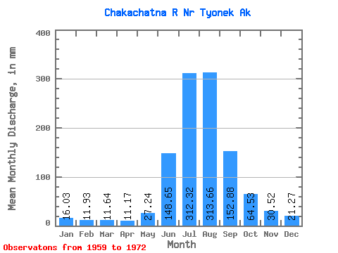
| Statistic | Jan | Feb | Mar | Apr | May | Jun | Jul | Aug | Sep | Oct | Nov | Dec | Annual |
|---|---|---|---|---|---|---|---|---|---|---|---|---|---|
| Mean | 16.03 | 12.03 | 11.64 | 11.17 | 27.23 | 148.66 | 312.27 | 313.62 | 152.88 | 64.52 | 30.52 | 21.26 | 1114.87 |
| Standard Deviation | 2.36 | 2.65 | 2.05 | 3.17 | 14.26 | 51.75 | 41.40 | 63.15 | 47.82 | 21.96 | 6.49 | 3.18 | 139.87 |
| Min | 12.55 | 9.07 | 8.49 | 6.33 | 12.31 | 53.50 | 260.37 | 220.01 | 84.70 | 35.32 | 22.81 | 16.99 | 907.12 |
| Max | 21.37 | 18.59 | 14.38 | 17.50 | 62.23 | 276.64 | 378.32 | 436.92 | 259.48 | 106.46 | 46.10 | 26.33 | 1390.19 |
| Coefficient of Variation | 0.15 | 0.22 | 0.18 | 0.28 | 0.52 | 0.35 | 0.13 | 0.20 | 0.31 | 0.34 | 0.21 | 0.15 | 0.12 |
 Return to R-Arctic Net Home Page