|
|
|||||||||||||||||
| Point ID: 9480 | Downloads | Plots | Site Data | Code: 15294350 |
|
|
|||||||||||||||||
| Download | |
|---|---|
| Site Descriptor Information | Site Time Series Data |
| Link to all available data | |
| View: | Time Series | All |
| Units: | mm |
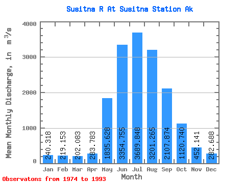
| Statistic | Jan | Feb | Mar | Apr | May | Jun | Jul | Aug | Sep | Oct | Nov | Dec | Annual |
|---|---|---|---|---|---|---|---|---|---|---|---|---|---|
| Mean | 240.32 | 219.15 | 202.08 | 283.78 | 1835.63 | 3354.76 | 3689.85 | 3201.26 | 2107.87 | 1120.74 | 452.14 | 282.69 | 1419.18 |
| Standard Deviation | 36.94 | 30.38 | 35.91 | 130.91 | 535.32 | 553.57 | 522.82 | 559.48 | 594.52 | 447.36 | 137.87 | 65.42 | 164.87 |
| Min | 176.75 | 158.97 | 152.00 | 164.71 | 1272.43 | 2574.95 | 2925.22 | 2468.77 | 1110.96 | 531.63 | 281.28 | 169.90 | 1187.55 |
| Max | 302.81 | 275.94 | 274.49 | 608.34 | 3425.43 | 4697.76 | 5135.40 | 4518.82 | 3275.03 | 2506.04 | 894.62 | 415.89 | 1647.46 |
| Coefficient of Variation | 0.15 | 0.14 | 0.18 | 0.46 | 0.29 | 0.17 | 0.14 | 0.17 | 0.28 | 0.40 | 0.30 | 0.23 | 0.12 |
 Return to R-Arctic Net Home Page