|
|
|||||||||||||||||
| Point ID: 9480 | Downloads | Plots | Site Data | Code: 15294350 |
|
|
|||||||||||||||||
| Download | |
|---|---|
| Site Descriptor Information | Site Time Series Data |
| Link to all available data | |
| View: | Time Series | All |
| Units: | m3/s |
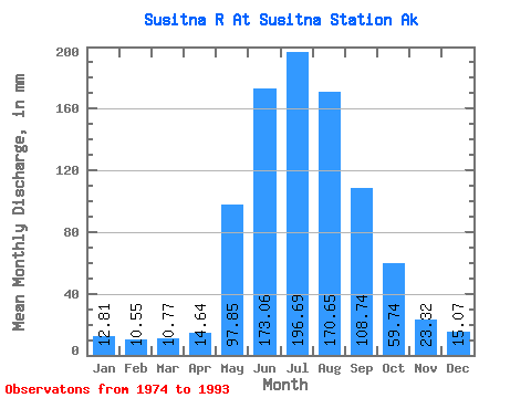
| Statistic | Jan | Feb | Mar | Apr | May | Jun | Jul | Aug | Sep | Oct | Nov | Dec | Annual |
|---|---|---|---|---|---|---|---|---|---|---|---|---|---|
| Mean | 12.81 | 10.64 | 10.77 | 14.64 | 97.83 | 173.06 | 196.66 | 170.62 | 108.74 | 59.73 | 23.32 | 15.07 | 891.40 |
| Standard Deviation | 1.97 | 1.48 | 1.91 | 6.75 | 28.53 | 28.56 | 27.86 | 29.82 | 30.67 | 23.84 | 7.11 | 3.49 | 103.56 |
| Min | 9.42 | 7.72 | 8.10 | 8.50 | 67.82 | 132.83 | 155.91 | 131.58 | 57.31 | 28.34 | 14.51 | 9.05 | 745.91 |
| Max | 16.14 | 13.40 | 14.63 | 31.38 | 182.57 | 242.34 | 273.71 | 240.84 | 168.95 | 133.57 | 46.15 | 22.17 | 1034.79 |
| Coefficient of Variation | 0.15 | 0.14 | 0.18 | 0.46 | 0.29 | 0.17 | 0.14 | 0.17 | 0.28 | 0.40 | 0.30 | 0.23 | 0.12 |
 Return to R-Arctic Net Home Page