|
|
|||||||||||||||||
| Point ID: 9451 | Downloads | Plots | Site Data | Code: 15275000 |
|
|
|||||||||||||||||
| Download | |
|---|---|
| Site Descriptor Information | Site Time Series Data |
| Link to all available data | |
| View: | Time Series | All |
| Units: | mm |
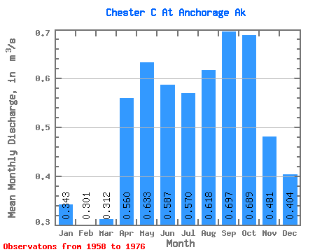
| Statistic | Jan | Feb | Mar | Apr | May | Jun | Jul | Aug | Sep | Oct | Nov | Dec | Annual |
|---|---|---|---|---|---|---|---|---|---|---|---|---|---|
| Mean | 0.34 | 0.30 | 0.31 | 0.56 | 0.63 | 0.59 | 0.57 | 0.62 | 0.70 | 0.69 | 0.48 | 0.40 | 0.53 |
| Standard Deviation | 0.16 | 0.14 | 0.13 | 0.21 | 0.25 | 0.26 | 0.22 | 0.21 | 0.28 | 0.29 | 0.20 | 0.19 | 0.17 |
| Min | 0.06 | 0.05 | 0.07 | 0.25 | 0.26 | 0.23 | 0.22 | 0.21 | 0.27 | 0.23 | 0.18 | 0.10 | 0.23 |
| Max | 0.66 | 0.54 | 0.54 | 0.99 | 1.04 | 1.34 | 1.10 | 0.98 | 1.36 | 1.39 | 1.00 | 0.83 | 0.81 |
| Coefficient of Variation | 0.46 | 0.45 | 0.41 | 0.37 | 0.40 | 0.45 | 0.38 | 0.35 | 0.41 | 0.42 | 0.43 | 0.47 | 0.33 |
 Return to R-Arctic Net Home Page