|
|
|||||||||||||||||
| Point ID: 9451 | Downloads | Plots | Site Data | Code: 15275000 |
|
|
|||||||||||||||||
| Download | |
|---|---|
| Site Descriptor Information | Site Time Series Data |
| Link to all available data | |
| View: | Time Series | All |
| Units: | m3/s |
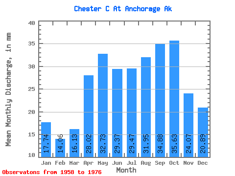
| Statistic | Jan | Feb | Mar | Apr | May | Jun | Jul | Aug | Sep | Oct | Nov | Dec | Annual |
|---|---|---|---|---|---|---|---|---|---|---|---|---|---|
| Mean | 17.74 | 14.20 | 16.12 | 28.03 | 32.72 | 29.38 | 29.48 | 31.93 | 34.88 | 35.61 | 24.05 | 20.86 | 320.43 |
| Standard Deviation | 8.09 | 6.44 | 6.56 | 10.47 | 12.95 | 13.16 | 11.31 | 11.04 | 14.24 | 14.95 | 10.26 | 9.88 | 105.20 |
| Min | 3.06 | 2.29 | 3.41 | 12.41 | 13.20 | 11.46 | 11.48 | 10.62 | 13.58 | 12.16 | 8.81 | 4.97 | 141.18 |
| Max | 34.24 | 25.58 | 27.91 | 49.41 | 53.65 | 67.02 | 56.82 | 50.82 | 67.97 | 71.97 | 50.25 | 42.84 | 496.31 |
| Coefficient of Variation | 0.46 | 0.45 | 0.41 | 0.37 | 0.40 | 0.45 | 0.38 | 0.35 | 0.41 | 0.42 | 0.43 | 0.47 | 0.33 |
 Return to R-Arctic Net Home Page