|
|
|||||||||||||||||
| Point ID: 9445 | Downloads | Plots | Site Data | Code: 15273900 |
|
|
|||||||||||||||||
| Download | |
|---|---|
| Site Descriptor Information | Site Time Series Data |
| Link to all available data | |
| View: | Time Series | All |
| Units: | mm |
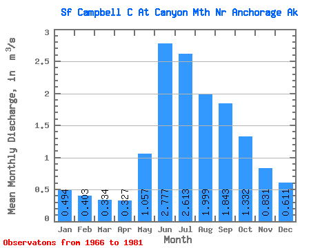
| Statistic | Jan | Feb | Mar | Apr | May | Jun | Jul | Aug | Sep | Oct | Nov | Dec | Annual |
|---|---|---|---|---|---|---|---|---|---|---|---|---|---|
| Mean | 0.49 | 0.40 | 0.33 | 0.33 | 1.06 | 2.78 | 2.61 | 2.00 | 1.84 | 1.33 | 0.83 | 0.61 | 1.13 |
| Standard Deviation | 0.10 | 0.07 | 0.05 | 0.04 | 0.48 | 0.78 | 0.95 | 1.07 | 0.87 | 0.49 | 0.22 | 0.12 | 0.25 |
| Min | 0.36 | 0.27 | 0.27 | 0.27 | 0.44 | 1.89 | 1.45 | 1.07 | 0.69 | 0.77 | 0.51 | 0.46 | 0.85 |
| Max | 0.68 | 0.56 | 0.42 | 0.41 | 1.97 | 4.37 | 5.12 | 4.25 | 3.46 | 2.54 | 1.28 | 0.82 | 1.73 |
| Coefficient of Variation | 0.20 | 0.18 | 0.15 | 0.11 | 0.45 | 0.28 | 0.36 | 0.54 | 0.47 | 0.37 | 0.26 | 0.20 | 0.22 |
 Return to R-Arctic Net Home Page