|
|
|||||||||||||||||
| Point ID: 9445 | Downloads | Plots | Site Data | Code: 15273900 |
|
|
|||||||||||||||||
| Download | |
|---|---|
| Site Descriptor Information | Site Time Series Data |
| Link to all available data | |
| View: | Time Series | All |
| Units: | m3/s |
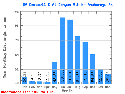
| Statistic | Jan | Feb | Mar | Apr | May | Jun | Jul | Aug | Sep | Oct | Nov | Dec | Annual |
|---|---|---|---|---|---|---|---|---|---|---|---|---|---|
| Mean | 20.27 | 15.04 | 13.69 | 12.99 | 43.35 | 110.22 | 107.16 | 82.00 | 73.16 | 54.61 | 32.97 | 25.05 | 547.46 |
| Standard Deviation | 4.12 | 2.79 | 2.06 | 1.45 | 19.64 | 31.03 | 38.85 | 44.00 | 34.40 | 20.24 | 8.59 | 4.99 | 118.69 |
| Min | 14.76 | 10.07 | 11.01 | 10.83 | 18.13 | 74.90 | 59.30 | 43.87 | 27.39 | 31.58 | 20.15 | 18.88 | 412.56 |
| Max | 27.89 | 21.09 | 17.23 | 16.15 | 80.76 | 173.25 | 210.18 | 174.31 | 137.47 | 104.10 | 50.69 | 33.57 | 834.98 |
| Coefficient of Variation | 0.20 | 0.18 | 0.15 | 0.11 | 0.45 | 0.28 | 0.36 | 0.54 | 0.47 | 0.37 | 0.26 | 0.20 | 0.22 |
 Return to R-Arctic Net Home Page