|
|
|||||||||||||||||
| Point ID: 9433 | Downloads | Plots | Site Data | Code: 15266500 |
|
|
|||||||||||||||||
| Download | |
|---|---|
| Site Descriptor Information | Site Time Series Data |
| Link to all available data | |
| View: | Time Series | All |
| Units: | mm |
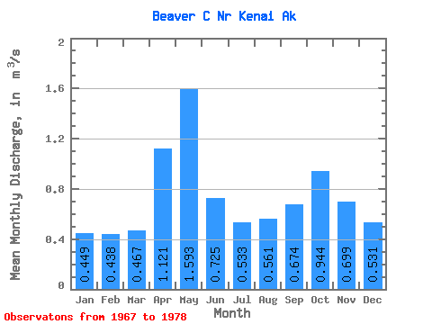
| Statistic | Jan | Feb | Mar | Apr | May | Jun | Jul | Aug | Sep | Oct | Nov | Dec | Annual |
|---|---|---|---|---|---|---|---|---|---|---|---|---|---|
| Mean | 0.45 | 0.44 | 0.47 | 1.12 | 1.59 | 0.72 | 0.53 | 0.56 | 0.67 | 0.94 | 0.70 | 0.53 | 0.73 |
| Standard Deviation | 0.14 | 0.15 | 0.16 | 0.62 | 1.00 | 0.18 | 0.11 | 0.26 | 0.15 | 0.40 | 0.28 | 0.22 | 0.11 |
| Min | 0.32 | 0.30 | 0.28 | 0.34 | 0.72 | 0.57 | 0.39 | 0.35 | 0.46 | 0.57 | 0.48 | 0.29 | 0.54 |
| Max | 0.75 | 0.74 | 0.83 | 2.40 | 3.56 | 1.10 | 0.72 | 1.27 | 0.92 | 2.05 | 1.41 | 0.94 | 0.92 |
| Coefficient of Variation | 0.32 | 0.35 | 0.34 | 0.56 | 0.63 | 0.26 | 0.21 | 0.46 | 0.23 | 0.42 | 0.41 | 0.41 | 0.15 |
 Return to R-Arctic Net Home Page