|
|
|||||||||||||||||
| Point ID: 9433 | Downloads | Plots | Site Data | Code: 15266500 |
|
|
|||||||||||||||||
| Download | |
|---|---|
| Site Descriptor Information | Site Time Series Data |
| Link to all available data | |
| View: | Time Series | All |
| Units: | m3/s |
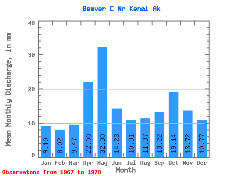
| Statistic | Jan | Feb | Mar | Apr | May | Jun | Jul | Aug | Sep | Oct | Nov | Dec | Annual |
|---|---|---|---|---|---|---|---|---|---|---|---|---|---|
| Mean | 9.10 | 8.10 | 9.48 | 22.00 | 32.29 | 14.22 | 10.81 | 11.38 | 13.23 | 19.13 | 13.72 | 10.77 | 174.09 |
| Standard Deviation | 2.94 | 2.84 | 3.27 | 12.23 | 20.24 | 3.62 | 2.24 | 5.25 | 2.98 | 8.05 | 5.58 | 4.40 | 26.20 |
| Min | 6.40 | 5.50 | 5.74 | 6.67 | 14.69 | 11.13 | 7.97 | 7.05 | 8.96 | 11.52 | 9.35 | 5.87 | 127.95 |
| Max | 15.22 | 13.62 | 16.91 | 46.99 | 72.18 | 21.59 | 14.66 | 25.77 | 17.98 | 41.57 | 27.63 | 19.15 | 218.91 |
| Coefficient of Variation | 0.32 | 0.35 | 0.34 | 0.56 | 0.63 | 0.26 | 0.21 | 0.46 | 0.23 | 0.42 | 0.41 | 0.41 | 0.15 |
 Return to R-Arctic Net Home Page