|
|
|||||||||||||||||
| Point ID: 9394 | Downloads | Plots | Site Data | Code: 15621000 |
|
|
|||||||||||||||||
| Download | |
|---|---|
| Site Descriptor Information | Site Time Series Data |
| Link to all available data | |
| View: | Time Series | All |
| Units: | mm |
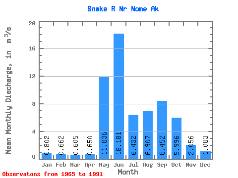
| Statistic | Jan | Feb | Mar | Apr | May | Jun | Jul | Aug | Sep | Oct | Nov | Dec | Annual |
|---|---|---|---|---|---|---|---|---|---|---|---|---|---|
| Mean | 0.80 | 0.66 | 0.60 | 0.65 | 11.84 | 18.18 | 6.43 | 6.91 | 8.45 | 6.00 | 2.06 | 1.08 | 5.29 |
| Standard Deviation | 0.29 | 0.26 | 0.24 | 0.27 | 8.00 | 12.54 | 3.94 | 4.58 | 6.93 | 3.33 | 0.90 | 0.36 | 1.40 |
| Min | 0.17 | 0.10 | 0.03 | 0.03 | 1.57 | 2.78 | 2.27 | 1.96 | 2.31 | 1.78 | 0.80 | 0.45 | 2.81 |
| Max | 1.60 | 1.28 | 1.13 | 1.18 | 27.55 | 46.85 | 14.93 | 18.59 | 33.49 | 15.13 | 4.42 | 2.10 | 8.29 |
| Coefficient of Variation | 0.36 | 0.39 | 0.40 | 0.41 | 0.68 | 0.69 | 0.61 | 0.66 | 0.82 | 0.56 | 0.44 | 0.34 | 0.26 |
 Return to R-Arctic Net Home Page