|
|
|||||||||||||||||
| Point ID: 9394 | Downloads | Plots | Site Data | Code: 15621000 |
|
|
|||||||||||||||||
| Download | |
|---|---|
| Site Descriptor Information | Site Time Series Data |
| Link to all available data | |
| View: | Time Series | All |
| Units: | m3/s |
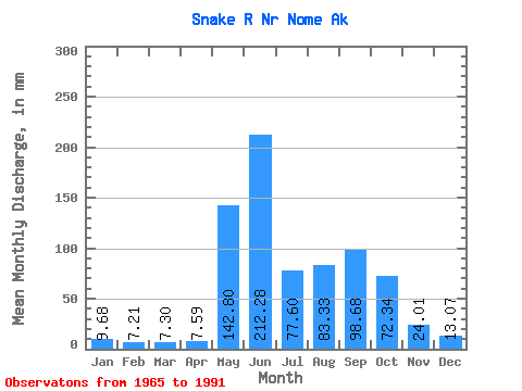
| Statistic | Jan | Feb | Mar | Apr | May | Jun | Jul | Aug | Sep | Oct | Nov | Dec | Annual |
|---|---|---|---|---|---|---|---|---|---|---|---|---|---|
| Mean | 9.67 | 7.27 | 7.30 | 7.58 | 142.78 | 212.27 | 77.59 | 83.31 | 98.69 | 72.33 | 24.00 | 13.06 | 752.79 |
| Standard Deviation | 3.50 | 2.83 | 2.94 | 3.13 | 96.55 | 146.43 | 47.55 | 55.21 | 80.88 | 40.11 | 10.52 | 4.40 | 199.03 |
| Min | 2.00 | 1.14 | 0.34 | 0.33 | 18.95 | 32.41 | 27.39 | 23.60 | 27.01 | 21.48 | 9.28 | 5.39 | 399.65 |
| Max | 19.34 | 14.12 | 13.67 | 13.76 | 332.29 | 547.02 | 180.04 | 224.31 | 390.99 | 182.52 | 51.58 | 25.34 | 1178.98 |
| Coefficient of Variation | 0.36 | 0.39 | 0.40 | 0.41 | 0.68 | 0.69 | 0.61 | 0.66 | 0.82 | 0.56 | 0.44 | 0.34 | 0.26 |
 Return to R-Arctic Net Home Page