|
|
|||||||||||||||||
| Point ID: 9380 | Downloads | Plots | Site Data | Code: 15300500 |
|
|
|||||||||||||||||
| Download | |
|---|---|
| Site Descriptor Information | Site Time Series Data |
| Link to all available data | |
| View: | Time Series | All |
| Units: | mm |
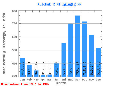
| Statistic | Jan | Feb | Mar | Apr | May | Jun | Jul | Aug | Sep | Oct | Nov | Dec | Annual |
|---|---|---|---|---|---|---|---|---|---|---|---|---|---|
| Mean | 443.33 | 387.90 | 347.32 | 315.53 | 317.59 | 405.23 | 553.27 | 702.45 | 759.42 | 715.64 | 616.94 | 518.49 | 498.96 |
| Standard Deviation | 89.67 | 85.49 | 102.33 | 97.42 | 77.91 | 82.43 | 116.23 | 189.25 | 213.44 | 193.21 | 157.57 | 115.52 | 102.41 |
| Min | 275.40 | 230.58 | 200.04 | 190.86 | 208.72 | 304.41 | 383.83 | 431.79 | 488.09 | 469.51 | 395.49 | 330.67 | 354.70 |
| Max | 586.52 | 537.01 | 660.88 | 624.76 | 510.62 | 550.76 | 793.33 | 1141.90 | 1220.27 | 1094.13 | 961.45 | 761.27 | 725.12 |
| Coefficient of Variation | 0.20 | 0.22 | 0.29 | 0.31 | 0.24 | 0.20 | 0.21 | 0.27 | 0.28 | 0.27 | 0.26 | 0.22 | 0.20 |
 Return to R-Arctic Net Home Page