|
|
|||||||||||||||||
| Point ID: 9380 | Downloads | Plots | Site Data | Code: 15300500 |
|
|
|||||||||||||||||
| Download | |
|---|---|
| Site Descriptor Information | Site Time Series Data |
| Link to all available data | |
| View: | Time Series | All |
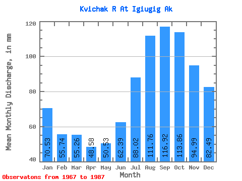
| Units: | m3/s |
| Statistic | Jan | Feb | Mar | Apr | May | Jun | Jul | Aug | Sep | Oct | Nov | Dec | Annual |
|---|---|---|---|---|---|---|---|---|---|---|---|---|---|
| Mean | 70.52 | 56.22 | 55.25 | 48.58 | 50.52 | 62.39 | 88.01 | 111.74 | 116.92 | 113.84 | 94.99 | 82.48 | 935.39 |
| Standard Deviation | 14.27 | 12.39 | 16.28 | 15.00 | 12.39 | 12.69 | 18.49 | 30.11 | 32.86 | 30.73 | 24.26 | 18.38 | 191.99 |
| Min | 43.81 | 33.42 | 31.82 | 29.39 | 33.20 | 46.87 | 61.06 | 68.69 | 75.15 | 74.69 | 60.89 | 52.60 | 664.94 |
| Max | 93.30 | 77.83 | 105.13 | 96.19 | 81.23 | 84.80 | 126.20 | 181.65 | 187.88 | 174.05 | 148.03 | 121.10 | 1359.36 |
| Coefficient of Variation | 0.20 | 0.22 | 0.29 | 0.31 | 0.24 | 0.20 | 0.21 | 0.27 | 0.28 | 0.27 | 0.26 | 0.22 | 0.20 |
 Return to R-Arctic Net Home Page